Today I Learned: Manila’s First Commercial Airport Was in Grace Park, Caloocan
The Japanese also converted a portion of Highway 54 (modern-day EDSA) into an auxiliary runway for fighter planes.
by Nick Aguila
Published on Aug 28, 2026
If you need to catch a flight out of Manila, you most likely have to make a beeline to the Ninoy Aquino International Airport, with its long queues, chaotic transfers, and familiar terminals. Some of us might choose to fly out from the airport in Clark, Pampanga, but it’s interesting to note that, for many of us, NAIA has been the one and only airport we’ve known to take us out of the city and welcome us back from our travels for decades now.
However, long before NAIA became the Philippines’ main international gateway, and even before Makati’s high-rises were built over the old runways of Nielson Field, the epicenter of Philippine aviation was located in the north.
Not a lot of people know that the country’s very first commercial airport was actually Grace Park Airfield way up in Caloocan. It might be tough to imagine it now, but if you’ve ever been there, you’ve likely stood directly on top of history without even realizing it.
ALSO READ
Today I Learned: The Story of One of the Last Pockets of Green in Pasig City
Today I Learned: The Story of the “Ghost Highway” Extension Along Katipunan Road in White Plains, QC
The story of Manila North Airport
Grace Park Airfield—officially pinned at Lat 14° 38' 0" N, Long 120° 59' 0" E—was located in the Grace Park subdivision of Caloocan, which was then a municipality of Rizal Province. In its heyday, the airport was widely known as “Manila North Airfield.” If you look at a historical map, the airfield was bordered perpendicular to the north by Highway 54 (which we now know as EDSA) and run diagonally parallel by Highway 52 (Rizal Avenue Extension).
Built prior to World War II, Grace Park opened in 1935. It served as the primary hub for the Philippine Aerial Taxi Company (PATCO), which pioneered commercial air travel in the country. Using Grace Park’s original turf “sod runway,” PATCO ran light aircraft services to Loakan Airfield in Baguio, largely catering to gold mining executives and tourists, along with several other domestic destinations. PATCO would eventually evolve to become Philippine Airlines (PAL).
However, Grace Park’s commercial dominance was brief. In July 1937, the more modern Nielson Airport opened in Makati, redirecting the bulk of international and domestic terminal operations south.
World War 2
When World War II swept through the Philippines, the Japanese military seized Grace Park Airfield. Recognizing its strategic value, they upgraded the airfield by constructing its first concrete surface runway.
Also, in an audacious engineering move, the Japanese converted a stretch of Highway 54 (modern-day EDSA) near the Balintawak Market into an auxiliary runway for fighter planes. Because of this, Grace Park became a prime target for the Allies. From September 1944 until January 10, 1945, American carrier aircraft and bombers relentlessly hammered the airfield.
The air battles were so intense they could be seen from a mile away. The website PacificWrecks quotes Curtis Brooks, a prisoner at the Santo Tomas Internment Camp located roughly one mile south, saying, “We had a good view of the air activity around the airfield. Grace Park was attacked by American Naval aircraft beginning in September 1944, as were all the other airfields and shipping installations in the Manila area.”
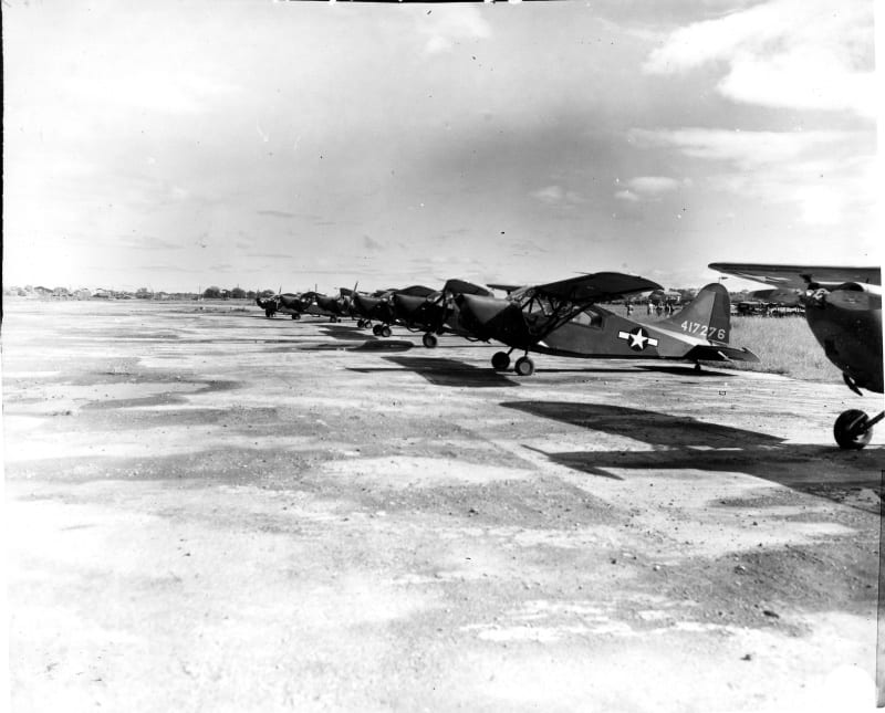
By late January 1945, during the liberation of Manila, the U.S. Army re-occupied the airstrip. While no U.S. Army Air Force (USAAF) units were permanently stationed there, the concrete strip became a frantic hive for Allied liaison planes—specifically Piper L-4 Cubs and Stinson L-5 Sentinels—used for observation flights and spotting artillery targets over the city.
This period yielded some wild, unsung stories of survival on the strip. SSgt Eugene Salternick recalled flying into the airfield with a very high-profile passenger.
“During the battle of Manila, we flew over Grace Park and I landed there in my L-5, with General Walter Krueger [commander of the U.S. Sixth Army] as a passenger,” he said. “We got out, parked the plane, and he went to do his inspection. When we were ready to leave, we heard a 'whoomp' and some mortars hit nearby. I ran back to the plane, fearing that they would have destroyed it but luckily it was not hit. We took off and got out of there quickly! This mortar crew must have been watching us when we landed, luckily their round missed.”
After the war officially ended, the airstrip remained an active military outpost. James A. Russo, Jr., who was stationed there alongside his twin brother between late 1945 and 1946, recalled flying L-4 Piper Cubs out of Grace Park for the Military Police and the CID.
What happened to the airfield
The airfield remained in active use until at least 1946. In 1948, commercial operations permanently shifted to Nichols Field in Pasay (the current site of NAIA and Villamor Airbase), and Grace Park was decommissioned.
Today, the airfield is entirely gone. The area has been completely developed into a dense residential and industrial urban center. There is no “park” and absolutely no physical trace of the runway.
However, aviation enthusiasts can still trace its exact footprint. The airfield was situated in Caloocan on Rizal Avenue Extension, spanning between 2nd and 11th Streets and the concrete runway built by the Japanese sat near where the Gotesco Grand Central Mall stands today.
Sources:
View More Articles About: