

Today I Learned: Many Flood-Prone Areas Are Where Streets and Creeks Intersect


Heavy rains from the Southwest Monsoon (Habagat) triggered floods in Metro Manila and nearby areas on Monday, July 21. Other roads saw up to head-deep floods in the evening, following the overflow of the La Mesa Dam and Wawa Dam at critical level on Monday afternoon. The Philippine Atmospheric, Geophysical, and Astronomical Services Administration warned that this weather is expected to persist in several parts of the country until Wednesday noon, with a warning of "widespread incidents of severe flooding and landslides."
Living in a tropical country, Filipinos have always known our two seasons: habagat from mid- to late May or June until October, and amihan during the other half of the year. The former, characterized by hot and humid weather, brings frequent heavy rainfall—and, obviously, floods. But, by experience, the flooding just gets worse every year (not to mention that the climate crisis is f*cking up weather patterns).
ALSO READ:
The City of Manila Could be Underwater by 2050 if Climate Change Isn’t Stopped
Animals for Sale Drown at Flooded Arranque Market in Manila
Street Floods in Metro Manila
Filipino geologist Mahar Lagmay, who's also behind the landmark initiative Project NOAH (Nationwide Operational Assessment of Hazards), reminded us of one of the root causes of urban flooding. "Ang totoong dahilan kung bakit binabaha ang mga kalye na nakikita natin ngayon sa social media. Daanan talaga siya ng tubig pero nilapatan natin ng kalye," he said in a post on July 21, 6:54 p.m. This is supported by a 2016 study, "Street floods in Metro Manila and possible solutions," published in the Journal of Environmental Sciences in 2017. Almost a decade after the research, the situation remains the same (or even worse), with solutions presented still not properly implemented.
"Metro Manila's floods are compounded by many factors including encroachment of concrete surfaces, densification of buildings and residential areas, silting of riverbeds and canals, obstruction of waterways by informal settlers, clogging of floodways by garbage, narrowing of rivers due to development on floodplains, draining and filling in of small rivers forcing more water into fewer channels, forest degradation, and reclamation of coastal land," the study concluded.
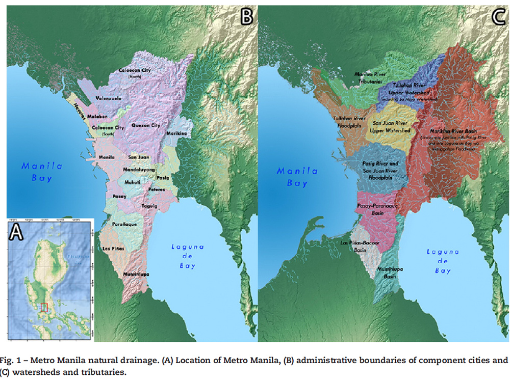
'Metro Manila is located on an isthmus between Manila Bay and Laguna de Bay. The entire region is composed of one major catchment called the Marikina River Basin, which covers 535 km2, and eight smaller, river sub-basins, which cover 683 km2 that drain directly into Manila Bay and Laguna de Bay. The Marikina, Pasig, San Juan and Tullahan rivers serve as the main outlets for a network of tributaries of the Marikina River Basin and smaller catchments of Metro Manila,' said the introduction of Lagmay et al.'s 'Street floods in Metro Manila and possible solutions'.
Lagmay and fellow researchers from the National Institute of Geological Sciences, University of the Philippines, compared the Metro Manila Development Authority's list of flood-prone areas in the National Capital Region with crowd-sourced data on flood experience on the ground. Field work was also conducted to check the drainage crossing the streets in these identified areas.
The results were clear: "The flood-prone areas list and flood-hazard maps show floods at intersections of streets and creeks, and at ponded areas." Moreover, street floods mostly occur at the lowest portion of the street (a.k.a. topographic lows) and are not elevated from roadsides and creek banks.
R. Papa in Manila, for example, is lower than the roadside and lies below the tops of three stream segments. Nine years after the study, floodwaters along R. Papa on July 21, 2025, at around 9 p.m., remain waist-deep and impassable to light vehicles. A quick online search shows that this has become a frequent scenario in that part of the capital. R. Papa, as it turns out, is just 1.38 meters above the creek bottom.
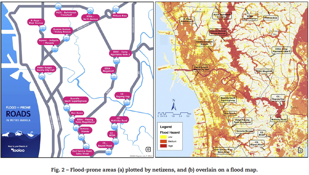
Other flood-prone areas identified by Lagmay et al. to be affected by its original topography are: Philcoa, which stands 3.8 m above the creek bottom; C-5 Bagong Ilog, which is 3.92 m above the stream bottom; Osmeña–Skyway, which is a 22.3-m bridge 3.34 m below street level; and Don Bosco, which has a stream with its bed 4.5 m below South Luzon Expressway. While these roads with creeks at the bottom are constructed with culverts and lateral drains, they are not designed for big floods, and even short-lived thunderstorms easily flood these streets.
The roads (and creeks) surrounding the University of the Philippines Diliman show an important contrast. A. Roces Avenue is 4 meters, while CP Garcia Avenue is 1.25 meters above the banks. The latter has a bigger channel, and the road is lower in elevation than the bank of the creek. "While it is built up above the lowest portion of the channel, it is still below the main channel banks," making it impassable even during short-lived torrential thunderstorms. This comparison shows that the construction of roads relative to the elevation of intersecting creeks affects their susceptibility to flooding.
"Humans have altered the landscape in the metropolis, which has grown rapidly but with poorly planned urbanization," causing street floods to happen mainly at intersections of streets and creeks, the study emphasized.
ALSO READ:
These Are the Lost Waterways in the City of Manila
What Flooding Was Like in the Philippines Back in the Day
Solutions to Metro Manila Flooding
The situation in A. Roces Avenue in UP Diliman, at least in the mid-2010s, may provide a possible solution: "a hydraulic structure under the street large enough to accommodate the volume of water, which is equivalent to the area covered by the flood multiplied by the height of inundation, which for Philcoa is only knee-high. The street surface must have steel mesh drains to accommodate the runoff that accumulates almost instantaneously in the topographic low. Ideally, the subsurface water retention area should drive flow into the creek. Constructing it below the street, if structurally feasible, avoids right-of-way problems." This proposed solution was simulated using a Flo-2D model and a Digital Elevation Model, which showed that the flood water was confined in strips rather than pouring on the road.
'Roads that follow topographic lows, even if they are above the creek's bank, should have enough clearance or freeboard to accommodate creek swelling,' Lagmay et al. said.
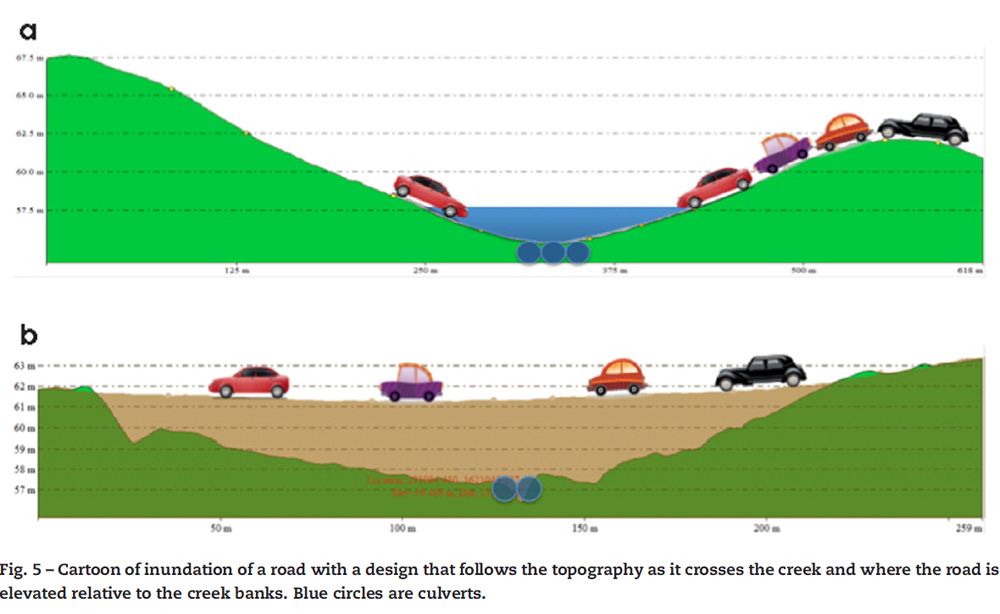
In other words, elevation of roads combined with the construction of a retention basin under the street that's big enough to accommodate the volume of water should be done. But it's not just any other retention basin. Lagmay et al. gave important conditions: "The size of the retention basin is equivalent to the simulated area covered by the flood along the street multiplied by the height of inundation. The street above the proposed retention basin must have enough infiltration capacity to accommodate the rapidly accumulated rainfall. The retention basin must also be designed to directly drain into the nearest stream channel."
Bonifacio Global City's all-underground utility system comes to mind when it comes to laudable flood mitigation. Underneath Burgos Circle, an open space and green area, is a 60-meter diameter storm water reservoir with a height of 12 meters (comparable to a four-storey building) and a capacity of 22,000 cubic meters of floodwater (equivalent to eight Olympic-sized swimming pools). This stormwater management and sustainable urban drainage system reduces flood peaks at the downstream areas of the development.
Source: Lagmay, A. M., Mendoza, J., Cipriano, F., Delmendo, P. A., Lacsamana, M. N., Moises, M. A., Pellejera, N., Punay, K. N., Sabio, G., Santos, L., Serrano, J., Taniza, H. J., & Tingin, N. E. (2017). Street floods in Metro Manila and possible solutions. Journal of Environmental Sciences, 59, 39–47.