
These Are the Lost Waterways in the City of Manila

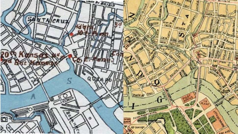
The Philippines is home to 1,019 bodies of water, ranging from inland freshwater (rivers, lakes, and groundwater), and marine (bay, coastal, and oceanic waters), according to the Department of Environment and Natural Resources. However, urbanization and industrialization not only reduce the quality of our waterways but also force reclamation to provide living space for our ever-growing population.
"Erecting structures on top of these lost bodies of water may be hazardous as these areas are prone to flooding after severe rainfall, or to liquefaction and amplified ground shaking during an earthquake," according to a group of researchers (Jubilo et al.) from the National Institute of Physics at the University of the Philippines Diliman and the Graduate School of Engineering at Kyoto University. In 2019, they published research that identified lost bodies of water in the Philippine major cities of Manila, Tacloban, Iloilo, Cebu, Davao, and Naga. These bodies of water either have shrunk in size or disappeared altogether, whether as a result of natural causes like sedimentation or human activity like reclamation.
ALSO READ
Many Flood-Prone Areas Are Where Streets and Creeks Intersect
What Flooding Was Like in the Philippines Back in the Day
Lost Waterways in Manila City
With its proximity to Manila Bay, Manila has several creeks, canals/esteros, and other tributaries that end up in the Pasig River, and then the bay. The visible ones include the 550-meter Estero de Balete in Ermita, Estero de la Reina in Binondo, Estero de San Miguel, and several others.


Jubilo et al. traced several small estuaries that have disappeared in Quiapo, based on two historical Manila maps (1899 and 1908). One of the lost estuaries now has a culvert, which likely channels water to what's now an underground waterway.
"The interviewed locals claim they do not experience flooding in their area. Yet they describe that the water level does rise during rain but lowers just as fast," said the researchers. But with flooding now seemingly normal, the locals may have gotten so used to it that they don't call it a catastrophe anymore.

Other waterways that have disappeared in Manila are a portion of Tomas Mapua Street in Santa Cruz, the area of what's now FEATI University in Quiapo until Carriedo and Paterno Streets, and the area of Technological Institute of the Philippines (draining to Estero de San Miguel) until the area of Minor Basilica of San Sebastian. Smaller lost waterways are also identified near Arlegui in Quiapo, near Arellano University (draining to Estero de Sampaloc), and by Matienza Street in San Miguel.
The researchers have also identified waterways that may still be underground, particularly the whole stretch of Quezon Boulevard in Quiapo to Dimasalang Street, as well as Lerma Street.
As Jubilo et al. mentioned, these places are prone to flooding and liquefaction. The lesser known of the two, liquefaction, poses a strong risk when the ground underneath a building is loosely packed or full of water-logged sediments. A sinkhole is one result of liquefaction.
Plus, there's the fact that the Philippines is the most vulnerable country to climate change according to the 2023 World Risk Index. In a 2023 public briefing by Namria Physical Oceanography Division, it was revealed that the level of Manila Bay has risen by 13.2 millimeters (mm) per year between 1947 and 2002, which can only exacerbate flooding in areas that once were bodies of water.
Images used with permission from Dr. Maricor Soriano, National Institute of Physics.
Source: Jubilo, Karol Giuseppe A., et al. “Lost Waterways: Clues from Digitized Historical Maps of Manila and other Philippines Cities.” The International Archives of the Photogrammetry Remote Sensing and Spatial Information Sciences, vol. XLII-4/W19, Dec. 2019, pp. 249–54.