

Experts Recommend 'Climate-Adaptive Governance' After Quezon City Flash Flood


Several parts of Quezon City were submerged in floodwater on Saturday afternoon, August 30. Videos and photos showed a torrent of floodwaters entering Mother Ignacia Avenue from EDSA, UP Lagoon became a bigger lagoon, Katipunan Avenue in Loyola Heights (which is on high grounds, as the name suggests) was flooded, and other barangays were inundated in head-deep water. The Quezon City Local Government Unit reported a total of 36 out of 142 barangays affected.
ALSO READ:
Why Metro Manila Is Prone to Widespread Flooding
Many Flood-Prone Areas Are Where Streets and Creeks Intersect
Flooding in Quezon City
While flooding is to be expected in low-lying and/or coastal areas, it isn't usual in places that aren't historically flood-prone. However, weather patterns are changing, and, unfortunately, urban planning cannot keep up.
Filipino geologist Mahar Lagmay and the University of the Philippines Resilience Institute (UP RI) gave a "detailed and accessible analysis based on the scientific findings" explaining the August 30, 2025, flooding in Quezon City. The findings, which integrate meteorological data, urban planning insights, and climate resilience principles, were posted online by Dr. Tony Leachon, with a Filipino translation.
It can be remembered that Lagmay is also the project head of Project NOAH (Nationwide Operational Assessment of Hazard), which was launched in 2012 as the Philippines' primary disaster risk reduction and management program under the Department of Science and Technology (DOST). It was officially defunded by the government in 2017 under the administration of former President Rodrigo Duterte, but the project was later adopted by the University of the Philippines. Its website is still accessible and able to show the probability and assessment of various areas in the Philippines in terms of Flood Hazard Level, Landslide Hazard Level, and Storm Surge Hazard Level.
Mahar Lagmay, during a press conference on the DPWH Flood Control Projects, last August 30.
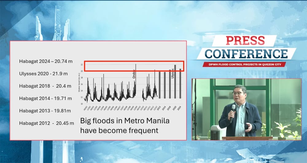
Why was Quezon City hit the hardest?
"The flooding was not Metro Manila-wide—it was hyperlocalized," started Lagmay. Data revealed that Quezon City and Nangka, Marikina, received an "extraordinary concentration of rainfall." The total rainfall in Quezon City for 24 hours was 141 mm, with a peak rainfall intensity of 121 mm/hour and a peak time between 2 p.m. and 3 p.m. For comparison, Typhoon Ondoy delivered approximately 90 mm/hour (still under review) of rainfall in 2009.
The Philippine Atmospheric, Geophysical and Astronomical Services Administration (PAGASA) also reported that the Science Garden Station between 2 p.m. and 3 p.m. indicated 96.6 mm of rain during an intense thunderstorm that affected northern Metro Manila and parts of Rizal. Meanwhile, PAGASA stations in Bulacan, Tanay, and Pasay did not record significant rainfall in the same period.
July rainfall in Quezon City is 568.5 mm, so the Saturday afternoon downpour is about five days of rain, the PAGASA report added.
Why were Quezon City's streets flooded so quickly?
"The flooding wasn’t just due to rain—it was due to rainfall delivered too fast for the city’s infrastructure to absorb or redirect."
It was a combination of many factors. First off, concrete and asphalt, which are common in urban spaces like Quezon City, are impermeable. This means that floodwater is not naturally absorbed. Second, drainage systems, even those recently upgraded, were not designed for this level of intense rain. Third, the short burst of extreme rainfall created flash flood conditions.
Not to mention recent issues in flood control projects, or lack thereof.
Was this kind of flooding foreseen?
"Yes—and this is where science meets governance."
The summary pointed out that the Quezon City Drainage Master Plan (QCDMP), developed in partnership with the UP RI, already identified flood-prone zones and mapped them using flood hazard simulations, historical rainfall data, and urban topography. Residents in these zones had been informed and capacitated to respond, according to the report, but the scale and speed of the rainfall exceeded typical preparedness thresholds.
A preliminary report is readily available online since April 2023, while the complete plans were turned over by the UP RI to the QC LGU on January 24, 2024. The QCDMP, according to a previous press release, is a two-year project of UP RI with the Quezon City Disaster Risk Reduction and Management Office, Office of the City Administrator, QC Engineering Department, and other relevant offices of Quezon City, with the aim to help provide solutions to the existing flooding problems of the city and serve as the long-term framework for flood management projects. The collaboration ran from July 2021 to December 2023.
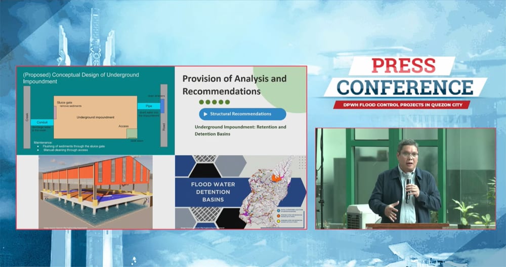
Lagmay's and UP RI's findings from the August 2025 Quezon City Flooding have three significant scientific takeaways.
First, climate events are localized. What's happening in one city may not be happening in another city at the same time. "Urban flooding is increasingly driven by microclimate anomalies—not just typhoons or seasonal monsoons."
Second, infrastructure must take into account peak hourly intensity, which is often the point when heavy flooding happens, instead of just total rainfall.
Third, drainage planning must be dynamic. Given the changes in weather patterns and microclimate anomalies, plans must evolve with climate data, urban expansion, and real-time monitoring.
Lagmay and UP RI have five recommendations:
- "Real-Time Rainfall Monitoring: Expand localized rain gauge networks and integrate with early warning systems.
- "Infrastructure Audit: Ensure all flood control projects align with the Drainage Master Plan and undergo environmental impact assessments.
- "Nature-Based Solutions: Incorporate green infrastructure—bioswales, permeable pavements, and retention parks—to absorb excess water.
- "Community Engagement: Continue capacitating residents in high-risk zones with drills, education, and access to emergency resources.
- "Climate-Adaptive Governance: Treat flooding not as a seasonal nuisance but as a climate resilience challenge requiring inter-agency coordination.
Flood Control Response of Pasig City and Cainta City
Pasig and Cainta are showing us how it's done.
Cainta Mayor Kit Nieto, in a post on Saturday night, explained a close coordination with Pasig Mayor Vico Sotto amid the intense rain in the Metro. Pasig and Cainta are located right next to each other, and given that these places are connected to the Pasig River and its tributaries, it's just common sense to coordinate flood response and control.
"Para sa mga residente ng Karangalan. Sa kasagsagan ng ulan kanina, nakatanggap ako ng text galing kay Mayor Vico tungkol sa floodgate na nilagay natin sa may Imelda Avenue papasok ng Karangalan. Ginawa natin ito para di mabulunan ang makitid nating creeks na daluyan ng tubig galing Pasig. Alam kasi natin na yung pumps na nilagay ng Pasig mga ilang taon na rin ang nakakaraan eh naitutok sa atin at naging dahilan ng mabilisang pagtaas ng tubig sa area ng Cainta," said Nieto in a post.
Karangalan Village, which is near Hakbangan Creek, is prone to knee-to-waist-deep flooding. The creeks flow to the Cainta River, which flows to the bigger Pasig River.
"Nakapag-usap kami weeks ago at nabanggit ko sa kanya na pwede nating itaas ang gate kung di nila paaandarin ang pump para free-flow lang ang tubig ulan pagdaan sa atin. Ngayong hapon, nagpaabot siya ng kasunduan na di paaandarin ang pumps nila at kung pwede na natin buksan ang flood gate, pumayag ako.
Sa Lunes, may team akong padadala para linisin ang naipong basura sa harap ng binuksang gate. Tuloy pa rin ang village-wide drainage clean up ng buong Karangalan para walang maging balakid sa pagdaloy at paglabas nito sa Cainta River.
Wala namang hindi naaayos sa sinsero at patas na pag-uusap. Salamat din, Mayor."
Sotto likewise explained in his announcement.
"F.Y.I. po sa mga taga-Brgy Dela Paz. Thank you very much Cainta Mayor Kit Nieto! Nasa post niya po kagabi ang detalye ng napagkasunduan namin (link in comment section): Bubuksan nila ang FLOOD GATE sa may Imelda Ave basta't di muna natin paandarin ang PUMPING STATION sa Karangalan," he said.
Dela Paz, like Cainta's Karangalan Village (and many parts of Metro Manila), is prone to knee-deep flooding.
"Nung nag-meeting kami ni Mayor Kit (Aug. 13), naipaliwanag niya nang malinaw kung bakit sila nagpagawa ng flood gate doon. Ang problema lang natin, pag sarado ito, bumabalik at naiipon ang tubig sa atin. Kaya ito na ang pinaka-'win-win' solution natin sa ngayon. May mga napag-usapan na rin kaming long-term improvements. 'Challenge area' talaga ang mga boundary lalo na't hindi lang naman LGU ang kailangan mag-usap dito," Sotto added.
The Pasig mayor also gave a reminder on the necessity of coordination among LGUs.
"Magandang paalala na rin ito sa atin na hindi talaga tayo puwedeng magkanya-kanya pag flood control ang usapan. Kailangan mag-improve kaming nasa gobyerno pagdating sa planning and coordination:
Ang problema ng mga kalapit na lugar at konektadong waterway ay problema rin natin (at vice versa). Kung anong sitwasyon ng tubig mula Upper Marikina River Basin sa Rizal hanggang Laguna de Bay, ay ramdam natin sa Pasig City.
Kaya ang sinusulong natin ngayon ay mas maayos na koordinasyon ng lahat mula national, regional, DPWH districts, LGUs, hanggang barangay hanggang HOA pa nga. Kung maayos ang konsultasyon, pagpaplano, at koordinasyon, tingin ko pati korapsyon mababawasan at gaganda ang mga programa."